TOP NSW DOG HIKES ARE:
- Pulpit Rock / Mount Piddington – Blue Mountains
- Mount York – Mount Victoria, Blue Mountains
- Hazelbrook – Blue Mountains
- Oxford Falls & Dee Why Regional Reserve – North Sydney
- Yellomundee Regional Park – Western Sydney
- Mermaid Pools and Tahmoor Gorge – South Sydney
- Blue Gums Hills Regional Park – Newcastle
- Chichester State Forest – Barrington tops
- Burringbar Rail Tunnel – Stokes Siding
- Bomaderry Creek Regional Park – Bomaderry, Nowra
- McDonald State Forest, Pointer Mountain – Manyana South Coast
- Mount Taylor Summit – Canberra
Finding great hikes to enjoy with your dog in New South Wales is really hard to find. I have been searching for years to come up with this list which are proper proper bush trials for you to explore. So put your hiking shoes on and grab your doggie booties, as you will need them on these trials.
It is banned for dogs to enter National Parks with some exceptions. However, dogs are permitted in state forest parks, crown land and regional parks which alot of these trails are. Some of these trails are also trials that are between suburban areas where the land is too steep to build on and the natural bush remained.
So many of the trails are easily accessible by 2WD and feature gorges, escarpments, rivers, creeks and waterfalls. Ive also tried to find trials that are more than just a short walk and focused my efforts finding bush tracks with multiple options and places to explore.
Pulpit Rock / Mount Piddington – Blue Mountains
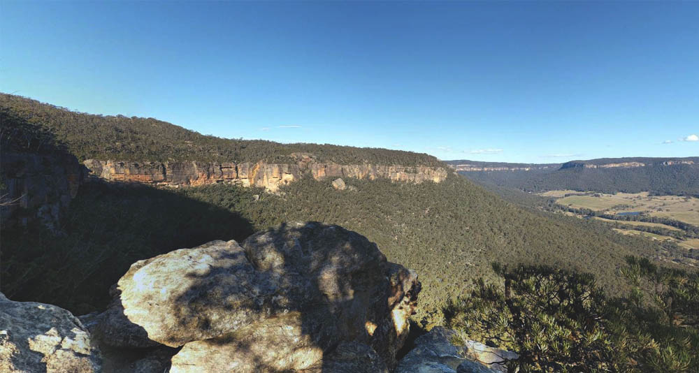
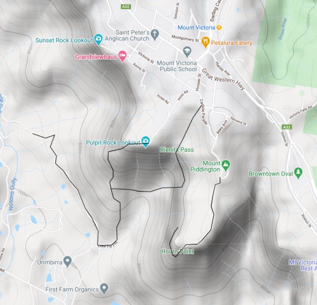
Up in the blue mountains, near Blackheath there is Mount Piddington which features spectacular scenic views. The trial consists of gorge cliffs where the path drops off to one side. Only do this if you’re an experienced hiker and not with little kids.
Also keep your dog on a leash at all times, as there are cliff dropoffs. There are loads of tracks to explore, many from Mount Piddington. These trails lead to the Ferris cave and cliffs which loop back to the starting point and to Horners Point which end at the cliffs.
There are several trails that lead through the bush but some aren’t official and either overgrown or not suitable for dogs as walking along the cliff becomes too dangerous.
The other track starts at Pulpit Rock Lookout and winds its way up little zig zag to the top of the escarpment. From here there are several more tracks that lead to the north towards wilsons gully. However you can loop back along the ridge heading to Rienits Pass Track.
I like this track as the sensory is spectacular, especially when you go exploring. Due to the different tracks you can go for a short hike or include the Wilsons Gully hike and make a full day of it.
Parking Coordinates:
Pulpit rock Lookout Parking -33.597119, 150.250345
Mount Paddinton -33.599254, 150.257535
Trail head: at car parks
Trail type: cliff walk, rainforest, rock out crops
Features: great views, caves, many tracks, waterfalls
Rules: keep on leash
Watch out for: snakes, rock climbers, abseilers, high tightrope walkers and a Bushranger
Take with you: Water, first aid kit with tick remove tool, GPS, extra battery for you phone
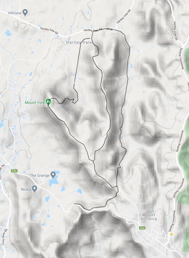
Mount York – Mount Victoria Blue Mountains
There are a multitude of different tracks to explore here which I have broken down into three options.
Option one: you can take the Berghofers pass for a short hike down the mountain that follows the old road. It’s about a 4 kilometers return walk.
Option two: if you want a more of a hike then the Cox road – Mt York Road – Lockyers Rd is a 12km loop which passes many lookouts and old convict elements to explore. If you park at Mt York car parking and then on your way back you will have to walk along the Mt York Road where you drove in for part of the hike.
Option three: the third option is another great loop of 11km, which follows Lawsons Long Alley which is a bush track that leads to a dirt road, Waltons Rd. Here you see some farm houses dotted along the creek. Follow the dirt road all the way until you reach the urban area of Hartley Vale in which you will come across the Comet Inn. Walk west along Hartley Vale road until you reach the Lockers track campground and sign ‘Lockeyers track head’ which is at the end of the large grouping of trees. This is where you rejoint the track. Once you enter you have two options to go either the high ridge or along the valley of cox road (which leads up to Mount York). Either way is great however the bush is dry and the track is dense low sclerophyll woodland and the path at times can be narrow and hard to see.
Parking Coordinates:
Option 1 and 3 -33.575607, 150.240495
Option 2 -33.553080, 150.220036
Trail head:
Option one: -33.575813, 150.240461
Option two: -33.552907, 150.220153
Option three: -33.575390, 150.240423
Trail type: thin bush trails, old dirt road, some asphalt road walking, some country fence lines
Features: lookouts, convict history
Rules: On leash
Watch out for: disappearing paths, approaching vehicles, feral pigs and snakes.
Take with you: Water, Knife, first aid kit with tick remove tool, GPS, extra battery backup for your phone
Hazelbrook – Blue Mountains
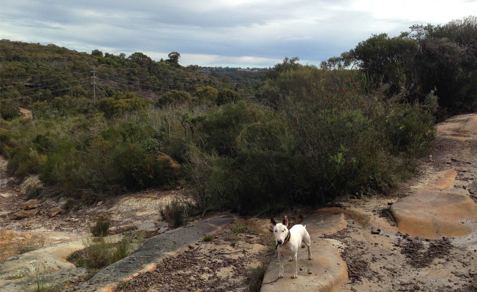
Hazelbrook features many walking trails that are not in the national parks so you can take your dogs. The trails that lead to the Bedford Creek feature cascading waterfalls and creek pools. It starts at the top of the escarpment and you make your way down to the creek below. Watch how the vegetation changes as you get to the bottom of the creek. Starting from dry sclerophyll open woodland to eventually fern like oasis at the bottom. These mini tracks are relatively easy and follow old fire trials and underneath rock outcrops. This is a great place to go in summer as the pools are quite refreshing.
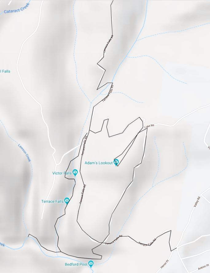
There are many trails that lead off the main Fire Trail Terrace Falls Rd that lead to many waterfalls and pools. There are spaces to park alongside the road so long as you don’t block the road. I suggest you park at the junction so you can complete a loop of Adams lookout – Bedford Pool – Terrace falls – Victor Falls in a clockwise manner or vice versa.
Parking Coordinates: Terrace Falls Rd dirt road junction -33.738506, 150.447704
Trail head:-33.738506, 150.447704
Trail type: dirt road, bush track, rock outcrops, creek beds
Features: waterfalls, lookout, outcrop ledges, pools
Rules: On leash
Watch out for: Monitor Lizards, snakes, Mountain bikers, approaching cars
Take with you: Water, first aid kit with tick remove tool, GPS extra phone battery
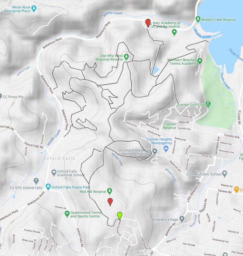
Oxford Falls & Dee Why Regional Reserve – North Sydney
Oxford Falls and Dee Why Regional Reserve area has many trials of varying difficulty. It encompasses a huge area that is divided by the several roads that cut through the bush. On the eastern side of the wakehurst parkway there are Red Hill Bushland Reserve which connects all the way to Narrabeen Lagoon trail. These tracks are mainly used by hikers and mountain bikers. There are many points where you can enter from.
Parking Coordinates: There are many points where you can enter from
Trail head: -33.743645, 151.256935, -33.734446, 151.262214, -33.728167, 151.265979, -33.717241, 151.263620
Features:. Rock outcrops, views to Narrabeen Lagoon, big hills, difficult terrain, Aboriginal rock engraving
Trail type: Open woodland, Heathland, Fire trials, rock scrambling and bouldering
Rules: stick to the paths, dogs on leash
Watch out for: Mountain bikers, dirtbikes, horse riders, snakes, fox baiting (there will be signs) & ticks (go in winter)
Take with you: Water, first aid kit with tick remove tool
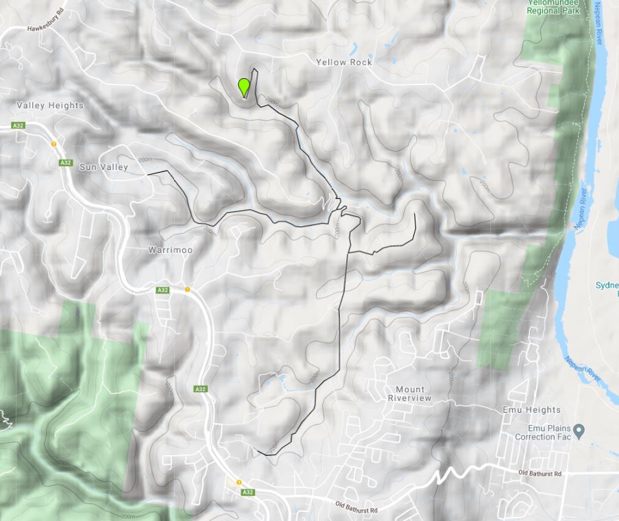
Yellomundee Regional Park – Western Sydney
Located in Springwood in Western Sydney at the base of the Blue Mountains on the western side of the Nepean River are many trials along the river beds. One that I would recommend is this 12 kilometer fire trail that follows the Long Apple Road fire trail, along Apple Creek, Fitzgeralds Creek and Valley Heights Creek. This also leads to the Warrimoo Lookout. There are a multitude of trails that meander between the suburbs. Start at the end of Long Angle Rd and work your way down to the creeks. This is a very scenic walk with tall eucalyptus forest and rocky gorges.
Parking Coordinates: -33.699070, 150.610288
Trailhead: -33.699070, 150.610288
Trail type: several tracks
Features: river crossing, falling tree, Lookouts
Rules: On Leash at all times, no dogs near playground or BBQ areas.
Watch out for: Monitor Lizards & snakes
Take with you: Water, first aid kit with tick remove tool
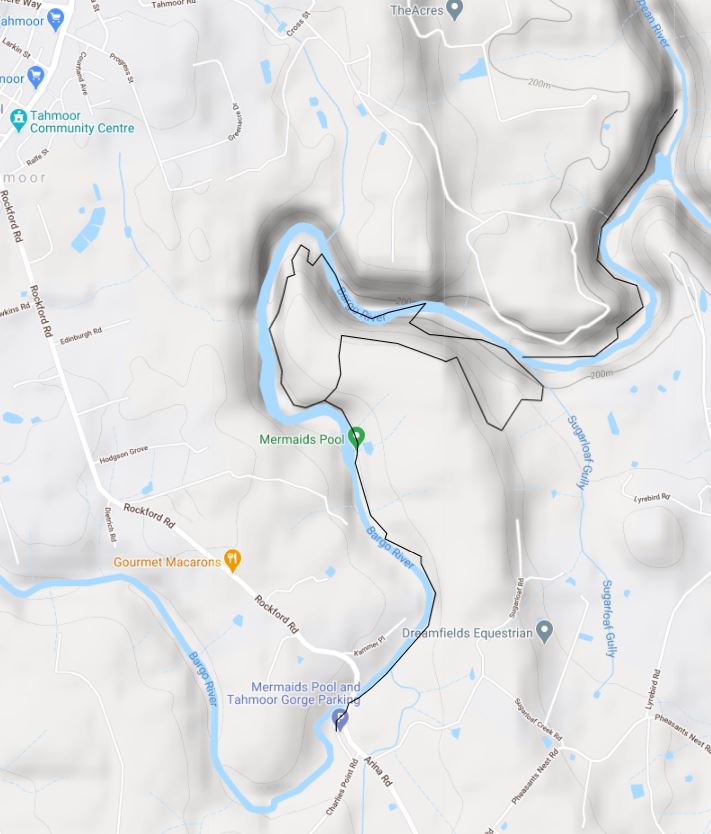
Mermaid Pools and Tahmoor Gorge – South Sydney
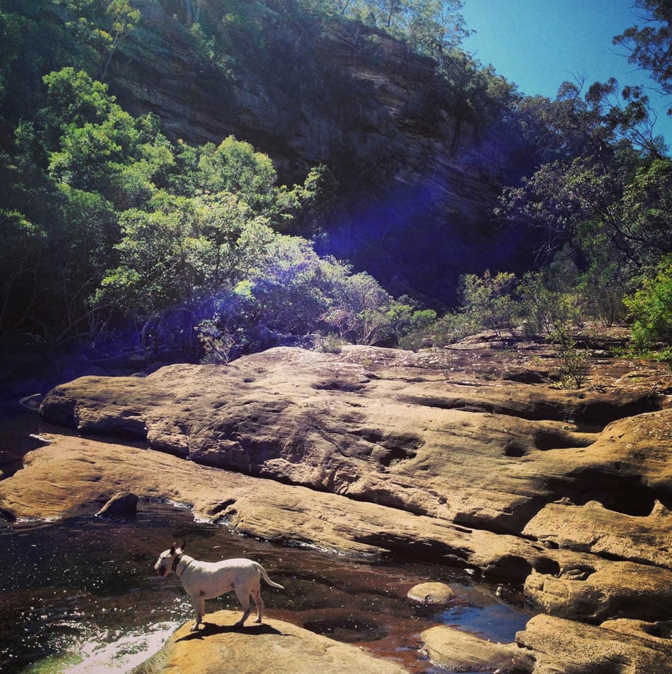
This track follows the Bargo River Gorge, sometimes your rock hopping along the river bed and other times you are on top of the gorge with fantastic views. This is one of my favorite spots to take my dog. Its a local favorite with kids who jump off jump rock into the pools. I’d advise against it as many injure themselves doing so. The track disappears a few times over larger rock out crops and it’s easy to lose your way as there are few markings. Some people have added makeshift markings like arrows on trees and on rocks. There is an upper path and lower path, however we did some exploring along the river which was low at the time and followed the river bed. The gorge is pretty cool.
Parking Coordinates: -34.250570, 150.606389
Trail head: start at the Rockford Rd Bridge crossing and head north east.
Trail Type: follow the river, there are lower and upper paths. After discovering the mermaids pool, keep going along the river discovering the gorge. Go as far as you want to go then head back via the ridge track.
Features: Mermaids pools, beautiful gorge
Rules: keep dog leashed and under control
Watch out for: Monitor Lizards (we saw a huge one) and snakes
Take with you: Water, first aid kit with tick remove tool
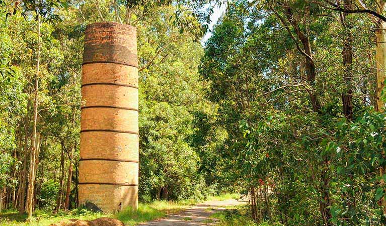
Blue Gum Hills Regional Park – Newcastle
This is one of the few NSW NPWS parks that you can take your dog. Its located at the Tree Top Adventure Park and has many facilities. The area used to be used by coal miners and has many historical features. There are many trails and tracks to go on which is also frequented by horse riders and mountain bike riders. This is ideal for exploring
Dog walking is permitted on lead and you need to keep your dogs away from the picnic and children’s play areas.
Parking Coordinates: -32.884893, 151.621184
Trail head: start from the carpark, several tracks loop back to main loop road and blue gums hills road.
Features: Historical Coal Mining features.
Trail type: Open woodland / Forest
Rules: On Leash at all times, no dogs near playground or BBQ areas.
Watch out for: Monitor Lizards, snakes & ticks – keep to the path.
Take with you: Water, first aid kit with tick remove tool
Chichester State Forest – Barrington Tops
At the foothills of Barrington Tops is the well known Chichester State Forest. This spot can get very busy with campers, 4×4/4WD, swimmers and hikers. I’d suggest to go mid week when it is quieter as this park has a lot to offer.
You can go on a small hikes at Peach Tree where you follow the Allyn River along the rainforest walking track, which is fairly short, however you can access the river and follow this which is pretty amazing. The rainforest trees are huge.
As you drive around, keep an eye out for old tracks, I went on one near a frying pan camping ground to a small waterfall which led to more exploring along the river beds.
Trail head: Peach Tree -32.128794, 151.474136 , Frying pan camping ground -32.218801, 151.761479
Features: Very scenic, River hiking, short 2WD car access hikes, facilities
Rules: keep on leash
Watch out for: kangaroos, approaching cars, snakes
Take with you: Water, first aid kit with tick remove tool
Burringbar Rail Tunnel – Stokes Siding
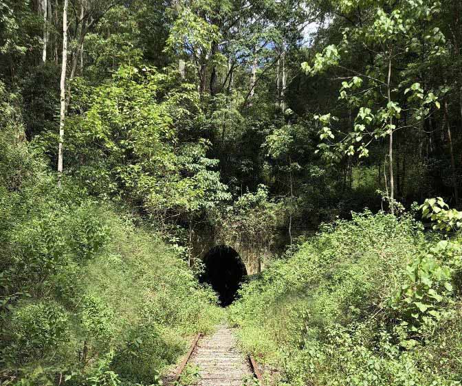
Burringbar Rail Tunnel track follows the abandoned rail line that goes for about 16kilometers. Its a local favorite for urban explorers and dog walkers. The rail line leads you to an old rail tunnel, which you need a torch. Keep an eye out for glow worms on the walls of the tunnel. Most have reported that the vegetation can at times be overgrown towards the end of the tunnel.
Parking Coordinates: –28.434094, 153.470663
Trailhead: –28.434094, 153.470663 (for the 16km out and back) or -28.409129, 153.422959 (for the 6km out and back)
Trail type: old Rail line complete with rail bridge and tunnel.
Features: Rail Line, tunnel
Rules: keep on leash,
Watch out for: watch out for snakes, feral pigs, ghost train
Take with you: Water, first aid kit with tick remove tool, torch, pocket knife
Google Map Link Tunnel Location
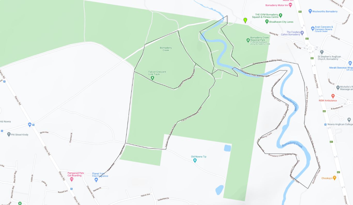
Bomaderry Creek Regional Park – Bomaderry, Nowra
This National park is one where you can take your dog. It has many features as a river crossing, cliffs, sandstone outcrops and and gorges. There are two main tracks: the Falcon Crescent Link Track which takes you into the gorge and creek. The other track is the She-Oak crossing walk which goes in a hidden gorge, creek and rainforest walk.
Parking Coordinates: Falcon Crescent -34.852804, 150.581987 or Narang Road -34.845004, 150.591385 for She Oak river walk
Trailhead: Falcon Crescent -34.852804, 150.581987 or Narang Road -34.845004, 150.591385 for She Oak river walk
Trail type: Forest / Gorges with inclines
Features: River crossing, rock outcrops, gorges
Rules: On Leash at all times, no dogs near playground or BBQ areas.
Watch out for: Monitor Lizards, snakes & ticks – keep to the path.
Take with you: Water, first aid kit with tick remove tool
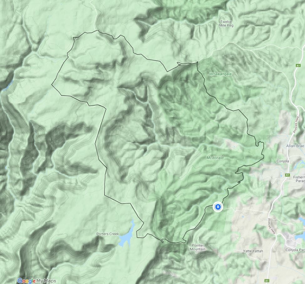
McDonald State Forest, Pointer Mountain Loop – Manyana South Coast
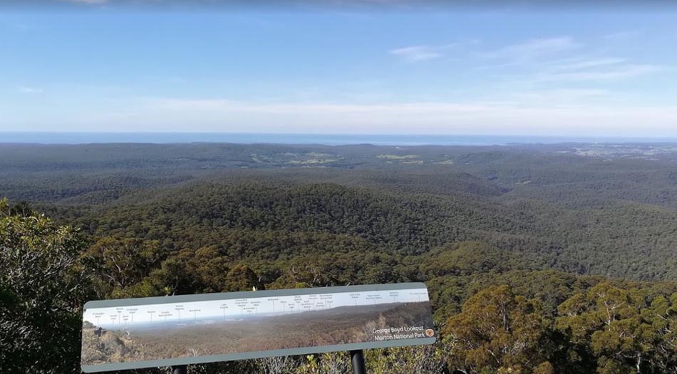
The Pointer Mountain Loop follows the old fire trail and access dirt roads of the Mcdonald state forest which is a 54 kilometer loop that travels up to the peak of Pointer Mountain and then back down towards the Pointers creek/dam which then loop back to the starting point. It has great views at George Boyed lookout at the top.
Parking Coordinates:
Trail head: -35.244791, 150.392459 head north from this point
Features: long day hike, views over Jervis Bay, forest, woodland, scrub, mt 680m, creek crossings.
Rules: dogs on leash
Watch out for: snakes, approaching vehicles, mountain bikes.
Take with you: Water, go with people, first aid kit with tick remove tool
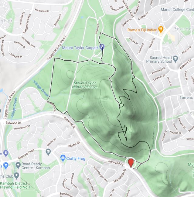
Mount Taylor Summit – Canberra
This one just made it in, as its a bit small but still a great little hike. Its well loved by the locals. Its an 8k mini mountain climb which is a mix of road base and dirt trails and has great views over the urban landscape. This one is good for all ages. Once parked just head up to the top and zigzag down the other side to make your way back. This trail had loads of runners and is popular at sunset and sunrise.
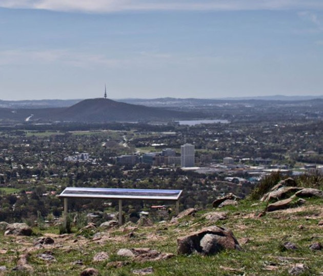
Parking Coordinates: -35.379795, 149.077013 or start on the other side -35.365023, 149.072228
Trail head:-35.379795, 149.077013 at the carpark and just head up the up to the top
Features: She Oak forest, views, Rural Art
Rules: dogs on leash
Watch out for: mountain bikers, snakes, Kangaroos
Take with you: water